


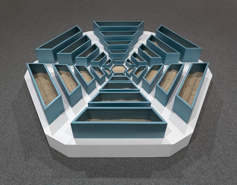
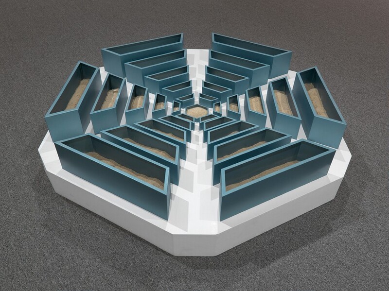
A Nonsite, Pine Barrens, New Jersey
1967 (Photostat of map); 1968 (Nonsite)
Artist, American, 1938 - 1973
Artwork overview
-
Medium
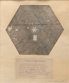
painted aluminum, sand, painted wood, and Photostat of map with typed text
-
Credit Line
-
Dimensions
overall (Nonsite): 30.48 × 166.37 × 166.37 cm (12 × 65 1/2 × 65 1/2 in.)
overall (Photostat of map with typed text): 32 × 27 cm (12 5/8 × 10 5/8 in.) -
Accession
2013.19.2.1
Associated Artworks
A Nonsite, Pine Barrens, New Jersey
Robert Smithson
1967
Artwork history & notes
Provenance
Virginia Dwan, New York; gift 2013 to NGA.
Associated Names
Exhibition History
1980
Robert Smithson: Sculpture, Herbert F. Johnson Museum of Art, Cornell University, Ithaca; Walker Art Center, Minneapolis; Museum of Contemporary Art, Chicago; La Jolla Museum of Contemporary Art; Laguna Gloria Museum, Austin; Whitney Museum of American Art, New York; American Pavilion, 40th Biennale, Venice; ARC, Musée d'art moderne de la ville de Paris; Sara Hilder Museum, Helsinki; Lehmbruck Museum, Duisberg; Museum of Modern Art, Belgrade; Kröller-Müller Museum, Otterlo, 1980-1984, no. S18 (1980-1982 catalogue for U.S. venues), S16 (Paris and Otterlo catalogues), repro.
2012
Ends of the Earth: Land Art to 1974, Museum of Contemporary Art, Los Angeles; Haus der Kunst, Munich, 2012-2013.
2014
Robert Smithson's New Jersey, Montclair Art Museum, Montclair, 2014, no. 6, repro.
Bibliography
2004
Graziani, Ron. Robert Smithson and the American Landscape. New York, 2004: 71, figs. 18(A), 18(B).
2013
Meyer, James. "Robert Smithson, A Non-Site (Pine Barrens, New Jersey) and Glass Stratum." National Gallery of Art Bulletin no. 49 (Fall 2013): 26-27, repro.
Inscriptions
lower right on map: R. Smithson 67; lower center, typed on label: A NONSITE (an indoor earthwork) / 31 sub-divisions based on a hexagonal / "airfield" in the Woodmansie Quadrangle - / New Jersey (Topographic) map. Each sub - / division of the Nonsite contains sand / from the site shown on the map. Tours / between the Nonsite and the site are possible. / The red dot on the map is the place where / the sand was collected.
Wikidata ID
Q63864424