Antonio Lafreri (Lafréry; French, 1512‒1577)
Pirro Ligorio (Italian, c. 1513‒1583)
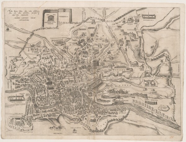
Urbis Romae, totius olim orbis domitricis, situs...
c. 1552–1573
Sheet Size: 57.2 x 44.5 cm
Etching and engraving
Collection of Fredrika and Paul Jacobs
Titled in full Urbis Romae, totius olim orbis domitricis, situs: cum adhuc extantibus, sacrosanctae vetustatis monumentis, this map bears the inscription PIRRHO LIGORIO NEAP. INVENTOR. Pirro Ligorio's topographical map was originally published in 1552 and was the first of its kind, inspiring later plans of Rome like those by Étienne Dupérac. This map was among the prints published in the Speculum Romanae Magnificentiae by Antonio Lafreri in the 1570s. This example represents an early state of Ligorio's map of the ancient city of Rome.
- Place Names
- Roman Forum (Campo Vaccino)
- Vatican (Apostolic) Palace
- Church of Trinità dei Monti
- Savelli Palace
- Church of Santa Maria del Popolo
- Church of Santa Maria in Aracoeli
- Piazza della Minerva
- Church of San Pietro in Carcere
- Church of San Luca
- Church of Santa Maria Maggiore
- Piazza Navona
- Rome
- Hospital of Santo Spirito
- Altemps Palace
- Capitoline Hill (Campidoglio)
- Church of Sant'Angelo in Pescheria
- Piazza Colonna
- Church of Santa Maria Rotonda (Pantheon)
- Church of Santa Maria dell'Orto
- Church of Santa Martina
Key to Map Annotations
The annotations (pins, polygons, and other shaded areas) indicate the following information relative to the maps over which they appear. These annotations can be toggled on or off using the "toggle annotations" dialogue box at the top left of the Mirador image viewer.
- Green/Verde: Churches/Chiese or other edifices as they are labeled on the map or noted in the legend on each map
- Blue/Azzurro: Identifiable churches or other edifices unlabeled on the map and unnoted in the legend
- Yellow/Giallo: Palaces/Palazzi
- Purple/Viola: Plazas/Piazze
- Orange/Arancio: Portals/Porte, Roads/Strade, or other