Skip to Main Content

Historical Journals as Digital Sources: Mapping Architecture in Germany, 1914-1924

Paul B. Jaskot, Andrew W. Mellon Professor (2014-2016)

Ivo van der Graaff, Postdoctoral Research Associate

with the assistance of Benjamin Zweig, Robert H. Smith Postdoctoral Research Associate

This project was initially developed by Paul B. Jaskot, Andrew W. Mellon Professor 2014-2016, during his residency at the Center for Advanced Study in the Visual Arts.

June 27, 2016

This site is devoted to an ongoing research project on the history of the construction industry in Germany from World War I through World War II. This project depends on both archival sources and digital mapping for its success. As part of the digital component, we are opening up our research here in the hope of encouraging feedback and contributions from interested colleagues. We provide a short overview of the project goals below, including working drafts of two of our maps. In addition, we are releasing part of our dataset. We encourage scholars to download the dataset over the next few months and to visualize components in ways different from our own. We see this as a community using digital and historical methods to expand and sharpen the quality of the work, that is, as a form of open peer review. The resulting Twitter conversations will be storified, and we will update the site with new information and visualizations as appropriate. The initial output will be the publication of an article on this topic.

file

Building sites in Germany displayed proportionally. 

This is a story of how visualizing historical evidence in a digital environment can expand the art-historical research process but also be a means of developing art-historical research questions in fundamental ways.

The project began in 2007 as a research topic focused on the World War II period that resulted from an ongoing collaboration with historical geographer Anne Kelly Knowles. Digital mapping of the spaces and places of the Holocaust showed that many concentration camps were focused on forced-labor construction activity, as opposed to the traditional narrative, which stressed their role in armaments production. It signaled the significance of the building industry for Nazi military, economic, and racist goals. These results also raised a deep-context follow-up question: what architectural and political role did the construction industry play more generally in Germany from World War I through World War II? This question needed a new approach, one that might be called an architectural history from below and that by necessity entails, for example, a discussion of labor and materials more than of design. The question has also raised problems involving art-historical sources, in particular how and even whether to visualize evidence in a digital mapping environment. 

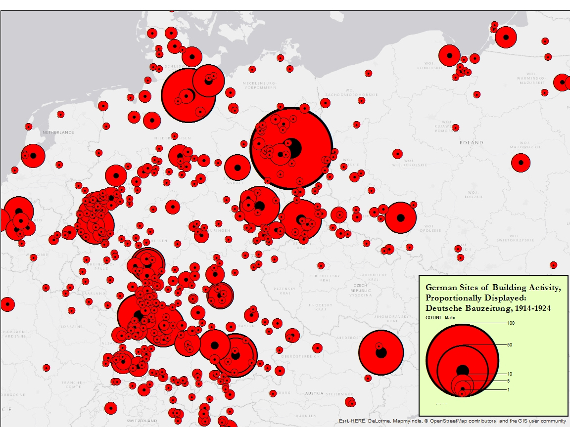
The real issue is, how does one research and then visualize for analysis a topic as big as a construction industry? This problem has crucial implications not only as a historical subject but also in terms of its relationship to the methodological process. Process here has a double meaning: it refers on the one hand to the historical subject of construction in Germany from World War I through World War II as a process of building in time, and, on the other, to methodology, to an analytical approach to the evidence. There is no single source for the construction industry, and its output of buildings, large and small, from vernacular to high-design, is impossible to capture. Digital methods, however, are meant to tackle large datasets, and the ability of geographic information systems (GIS) to map spatial information can help us to address this large-scale problem. 

file

Church and Synagogue construction sites. 

But while GIS has obvious applicability in relation to the quantity of building activity, it faces the daunting problem of the quality of the data. The task of going to every German locality to record every building permit, looking at the archive of every architect, mining every newspaper and trade journal for building activity, or somehow getting access to all construction firms’ archives is near impossible. It is too big and has too many evidentiary gaps to make it viable. The evidence is also too hazy to be relevant for the Cartesian methodological framework of GIS. Hence, we need a different synthesis of the use of historical sources relating to building activity and digital mapping methods. Such a synthesis allows us to investigate the scale of the problem through the nature of the evidence.

Naturally, historical sources like journals are never completely interpretive, any more than quantitative methods ever produce a transparent representation of reality. Nevertheless, each mode of analysis is indexical to the real of society. That is, it exists in relation to the actions and structural conditions of human production and reception. This is a fundamental premise of the social history of art, and something that Arnold Hauser discusses as the irreducible mediation between the meaning of a work of art and its social conditions. Combining the relational capacity of evidence from historical journals and the methods of digital mapping is a powerful means of visualizing the social dynamics and significance of architectural production.

Visualization in this sense is morphological. It gives form to otherwise hidden connections between individual objects and social developments. Digital mapping exposes new problems and areas of research around the mediating role that culture itself takes in developing and reproducing dominant social structures. We argue that mapping historical journals can point to potential activators or inhibitors of social and cultural change. Such a visualization is a morphological intermediary step that gives shape to the social by reforming the evidence and its biases. It can lead to patterns and results that we can analyze as the characteristic relational factors of a social system―in this case, the complex society of Germany during World War I and in the early Weimar Republic. There are, of course, limitations (the journals' editorial bias and human error in recording), but visualizing databases through historical journals gives form to human actions and structural patterns that redirect the art-historical question from the object to what construction may tell us about society as a whole. In the process, it allows us to see in new ways a much broader history of German architecture from 1914 to 1924.

September 12, 2016

View the Peer Review on Storify

DBZ 1914_24 L.All.16 Pt Symbols.8_31_1510

All sites of building activity. 

As we finished the draft of our dataset, we realized that much of our initial experimentation in GIS would be at the level of the building typology field. But we had also populated the dataset with other kinds of information, including everything from names of buildings, to names of architects if known, to when projects were published in the journal and how often. We thought that information about frequency of appearance might allow us to capture editorial bias. Yet given that we were doing the GIS geocoding and mapping explorations at the typology level, we wondered if others might have different and fruitful approaches to the other evidence fields. Hence our decision, a bit unusual in digital humanities, to release our dataset to the public. We adopted the model of peer review because we valued a critical engagement with the dataset that would assess the way it is structured, how useful the extracted evidence may or may not be, and whether it can be extended to other projects or should be continued with other journals. Since extracting the data is a big commitment—we all know what it means to read a historical journal page by page in order to gather complete documentation of a subject—we wanted to see whether others thought our process was helpful and rigorous. In addition, we felt strongly that other digital projects in art history should release their data, even at preliminary stages, in order to provide structured data for those who may find it useful or may be preparing to start their own work. While our main objective was to interrogate our evidence and how it was organized, this advocacy role was also something that we had in mind for a public discussion of our dataset.

dispersion_ny-1

Matthew Lincoln: Graph callibrated to show building construction from perspective of Berlin. 

In view of these goals, the online peer review was a mixed success. On the one hand, it showed us the difficulty of using a Twitter conversation to reach a larger audience. Given the competition online as well as the informality of the format, we found that release of the information was not in itself sufficient to gain attention. We missed two core groups of the German historical community as well as the geography community. We were pleased to receive e-mails and comments from scholars from both of these groups after the fact, but we wonder if a different approach to timing may be required to gather interested people in an online environment. It might have helped, for example, to have this conversation as a kind of add-on to a German studies or digital humanities conference.

Zweig_JSON_Visualization

Benjamin Zweig: Sample from dataset converted to JSON and visualized as simple tree hierarchy.

On the other hand, we were pleased with the rigor of the art-historical response. The main participants did indeed do what we had hoped. They critiqued some basic problems with the dataset and forced us to clarify fields and decisions that were not transparent. In addition, they offered substantive discussion of how such art-historical evidence can be approached or visualized in different ways and with different questions. In particular, we came away with confirmation that there are many more ways of parsing the evidence than we had imagined. We also found the editorial bias fields to be helpful as we turn toward other possible journal datasets. All in all, we were happy with the quality and quantity of the feedback as part of the ongoing intellectual project (and process) of analyzing the German construction industry from World War I through World War II.