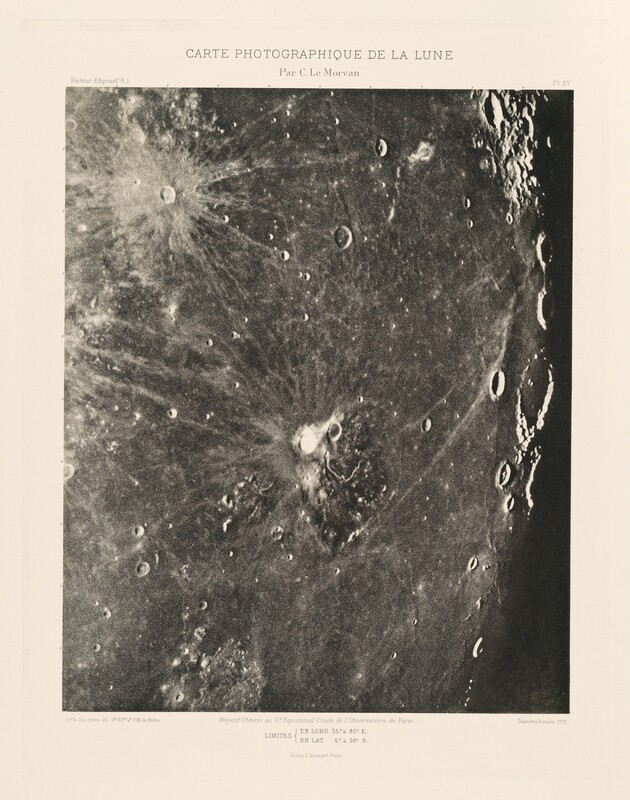
Carte photographique de la lune, planche XV (Photographic Chart of the Moon, plate XV)

December 20, 1904, printed 1914

Charles le Morvan

Associated Names
Charles Le Morvan

Artist, French, 1865 - 1933

This is a photograph showcasing the lunar surface with its cratered terrain. The image displays a detailed view of the Moon's surface, highlighting various craters of different sizes. The largest crater is featured near the center with distinct rays emanating outward. Many smaller craters are scattered across the lunar landscape, indicating the surface's ancient and dynamic history. The contrast in the photograph captures the variations in the lunar surface, emphasizing its topographical features. The text above the image identifies it as a photographic map of the Moon titled "Carte Photographique de la Lune" by C. le Morvan, with specific coordinates provided at the bottom.

Media Options

This object’s media is free and in the public domain. Read our full Open Access policy for images.

Artwork overview

  • Medium

    photogravure with ink on tissue paper overlay

  • Credit Line

    Pepita Milmore Memorial Fund

  • Dimensions

    image: 31.1 × 25.5 cm (12 1/4 × 10 1/16 in.)
    plate: 38.9 × 29.5 cm (15 5/16 × 11 5/8 in.)
    sheet: 49 × 37.9 cm (19 5/16 × 14 15/16 in.)
    tissue: 42.55 × 37.47 cm (16 3/4 × 14 3/4 in.)

  • Accession Number

    2018.22.1.15

  • Portfolio Title

    Carte photographique et systématique de la lune (Photographic and Systematic Chart of the Moon)

Associated Artworks

See all 48 artworks

Carte photographique de la lune, planche I (Photographic Chart of the Moon, plate I)

Charles Le Morvan

1909

This is a printed cover page from a publication titled "Carte Photographique et Systématique de la Lune" by M.C. Le Morvan. The cover features bold, large lettering and includes diagrams of the moon's phases, which are divided into sections labeled with Roman numerals. The text indicates the publication is a heliogravure process by L. Massard and is supported by the Académie des Sciences in Paris. It is dated MDCCCCXIV, which corresponds to the year 1914. The overall design is formal and informative, with a focus on astronomical content, likely intended for scientific or educational purposes.

Carte photographique et systématique de la lune (Photographic and Systematic Chart of the Moon)

Charles Le Morvan

1914

This is a photograph of the surface of the Moon. The image displays a detailed capture of the lunar surface, showcasing a landscape dominated by craters of varying sizes, some overlapping while others stand isolated. The texture of the lunar surface is rugged and uneven, revealing variations in shading that indicate the depth and contours of the terrain. The monochrome palette emphasizes the contrast between the cratered regions and the smoother plains. The arrangement and density of the craters suggest a heavily impacted surface over millions of years. The photograph includes text annotations detailing specific coordinates and technical information.

Carte photographique de la lune, planche II (Photographic Chart of the Moon, plate II)

Charles Le Morvan

1902


Artwork history & notes

Provenance

(Rick Watson, London); NGA purchase, 2018.

Associated Names

Inscriptions

top center in plate mark typed in black ink: CARTE PHOTOGRAPHIQUE DE LA LUNE / Par C. Le Morvan; upper left: Facteur d’Agrand t. 6.1; upper right: PL. XV; lower left: 1904 Décembre 20 9h. 32m. 4s. T.M. de Paris; lower center: Négatif Obtenu au Gd. Equatorial Coudé de l’Observatoire de Paris; lower right: Diamètre lunaire 1m. 01; bottom center: LIMITES { EN LONG. 35°. à 80°. E. / EN LAT. 6°. à 38°. N. / Héliog. L. Massard Paris.


You may be interested in

Loading Results