Novi Belgii Novaeque Angliae nec non Pennsylvaniae et partis Virginiae tabula multis in locis emendata

c. 1684

Justus Danckerts

Associated Names
Justus Danckerts

Artist, Dutch, 1635 - 1701
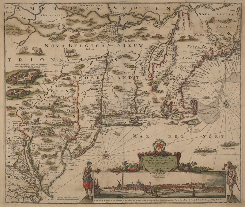
This is a historical map of the Northeastern United States and surrounding areas. The antique map features detailed illustrations of land masses, rivers, settlements, and decorative elements. Various regions such as NOVA BELGICA and NIEUW NEDERLANDT are labeled, along with artistic representations of animals like beavers and deer. Pictorial elements include a cityscape at the bottom, possibly representing New Amsterdam, and a decorative cartouche featuring figures and a ship. The geography is shown in a stylized manner typical of cartographic works from the period, with lines indicating colonial borders and paths of exploration.

Media Options

This object’s media is free and in the public domain. Read our full Open Access policy for images.

Artwork overview

  • Medium

    engraving with hand coloring on laid paper

  • Credit Line

    Gift of R. Horace Gallatin

  • Dimensions

    sheet: 53.5 × 63 cm (21 1/16 × 24 13/16 in.)
    plate: 46.3 × 55.2 cm (18 1/4 × 21 3/4 in.)

  • Accession Number

    1949.1.60


Artwork history & notes

Exhibition History

2007

  • Fabulous Journeys and Faraway Places: Travels on Paper, 1450 - 1700, National Gallery of Art, Washington, D.C., 2007

Inscriptions

recto: in plate, at lower right: Novi Belgii / Novaeque Angliae nec non / Pennsylvaniae et partis / Virginiae tabula / multis in locis emendata. a / Iusto Danckers / Nieuw Yorck. / eertys Genaemt / Nieuw Amsterdam / opit Eylant Manhattans

Markings

none

Wikidata ID

Q65080274

You may be interested in

Loading Results