

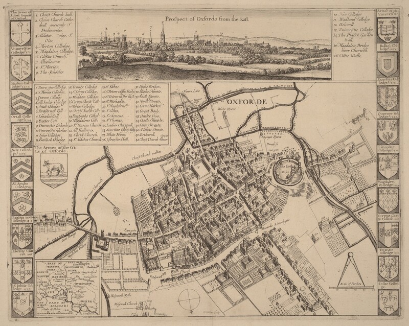
Prospect of Oxford
1652-1677
Wenceslaus Hollar after D. Gage
Associated Names
Wenceslaus Hollar
Artist, Bohemian, 1607 - 1677
D. Gage
Artist After, English, active 17th century
This object’s media is free and in the public domain.
Read our full Open Access policy for images.
Not on view
See artworks now on view
Artwork overview
-
Medium
etching
-
Credit Line
-
Accession Number
1943.3.4936
-
Catalogue Raisonné
New Hollstein, no. 2523, State i/ii
Artwork history & notes
Bibliography
1982
Pennington, Richard. A Descriptive Catalogue of the Etched Work of Wenceslaus Hollar 1607-1677. Cambridge: Cambridge University Press, 1982.
1996
The New Hollstein German Engravings, Etchings and Woodcuts, 1400-1700. (Wenceslaus Hollar, Simon Turner, author). Rotterdam: Sound & Vision Interactive, 1996-, undescribed (see no. 436).
Wikidata ID
Q65026603