Jan van Vianen (Dutch, 1660‒1726)
Jan Goeree (Dutch, 1670‒1731)
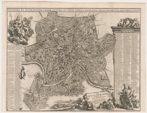
Giovanni Battista Falda (Italian, 1648‒1678)
Novissima et accuratissima Romae veteris et novae tabula topographica delineatore
1694–1699
Sheet Size: 15.4 x 15.3 cm
Etching and engraving
Collection of Fredrika and Paul Jacobs
Reduced in scale from Falda's Nuova pianta et alzata of 1676 and adapted by Jan Goeree and printed by Jan van Vianen, this map is titled Novissima et accuratissima Romae veteris et novae tabula topographica delineatore. A Dutch title appears in a separate cartouche, Niewe en naukeurige afbeelding van oud en niew rome, getekent door Joan Baptist Falda.
- Place Names
- Church of Sant'Agata dei Goti
- Vatican (Apostolic) Palace
- Farnese Palace
- Church of San Nicola in Carcere
- Church of Trinità dei Monti
- Piazza della Minerva
- Piazza di San Lorenzo in Lucina
- Piazza Navona
- Rome
- Hospital of Santo Spirito
- Altemps Palace
- Capitoline Hill (Campidoglio)
- Church of Sant'Angelo in Pescheria
- Church of Santa Maria Rotonda (Pantheon)
- Church of Santa Maria dell'Orto
- Church of Santa Martina
- Church of San Luigi dei Francesi
- Roman Forum (Campo Vaccino)
- Church of Santi Luca e Martina (San Luca and Santa Martina)
- Church of San Lorenzo ai Monti
- Church of San Giovanni dei Fiorentini
- Savelli Palace
- Church of Santa Maria del Popolo
- Church of Santa Maria in Aracoeli
- Church of San Pietro in Carcere
- Crescenzi Palace
- Via Frattina
- Church of San Luca
- Church of San Lorenzo in Lucina
- Church of Santa Maria sopra Minerva
- Church of Santa Maria Maggiore
- Church of San Nicola dei Lorenesi
- Piazza Colonna
- Oratory of Sant'Orsola della Pietà
- Borgo di Sant'Agata
- Church of Santa Maria di Loreto
- Church of San Giuseppe dei Falegnami
- Church of Sant'Atanasio dei Greci
Key to Map Annotations
The annotations (pins, polygons, and other shaded areas) indicate the following information relative to the maps over which they appear. These annotations can be toggled on or off using the "toggle annotations" dialogue box at the top left of the Mirador image viewer.
- Green/Verde: Churches/Chiese or other edifices as they are labeled on the map or noted in the legend on each map
- Blue/Azzurro: Identifiable churches or other edifices unlabeled on the map and unnoted in the legend
- Yellow/Giallo: Palaces/Palazzi
- Purple/Viola: Plazas/Piazze
- Orange/Arancio: Portals/Porte, Roads/Strade, or other