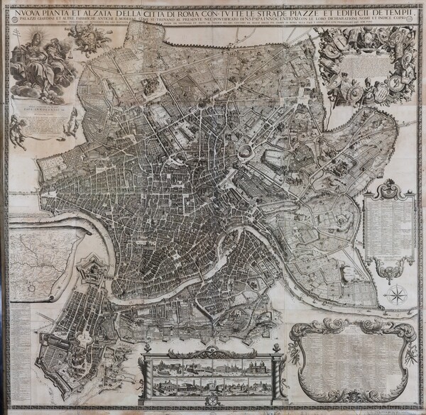
Giovanni Battista Falda (Italian, 1643‒1678)
Nuova pianta et alzata della città di Roma…
1676
12 plates
Overall Dimensions: 157 x 155 cm
Sheet Size: 39 x 51 cm
Etching and engraving
Biblioteca di Archeologia e Storia dell’Arte, Rome. Image copyright: Rome, Biblioteca di Archeologia e Storia dell’Arte; Photograph: Mauro Coen
Falda’s map is titled in full Nuova pianta et alzata della città di Roma con tutte le strade, piazze, et edificii de tempii: palazzi giardini et altre fabriche antiche et moderne come si trovano al presente nel pontifcato di N.S. Papa Innocentio XI con loro dichiarationi: nomi et indice copiosissimo. It shows the full extent of building projects and changes to the fabric of the Eternal City over the course of the century represented in maps dating from 1577 to 1676. For example, Falda’s scenographic view allows us to see the recently completed facade and exterior walls of the Church of Santi Luca e Martina, designed by Pietro da Cortona, which belongs to the Accademia di San Luca to this day.
- Place Names
- Church of Sant'Agata dei Goti
- Vatican (Apostolic) Palace
- Farnese Palace
- Church of San Nicola in Carcere
- Church of Trinità dei Monti
- Piazza della Minerva
- Piazza di San Lorenzo in Lucina
- Piazza Navona
- Rome
- Hospital of Santo Spirito
- Altemps Palace
- Capitoline Hill (Campidoglio)
- Church of Sant'Angelo in Pescheria
- Church of Santa Maria Rotonda (Pantheon)
- Church of Santa Maria dell'Orto
- Church of Santa Martina
- Church of San Luigi dei Francesi
- Roman Forum (Campo Vaccino)
- Church of Santi Luca e Martina (San Luca and Santa Martina)
- Church of San Lorenzo ai Monti
- Church of San Giovanni dei Fiorentini
- Savelli Palace
- Church of Santa Maria del Popolo
- Church of Santa Maria in Aracoeli
- Church of San Pietro in Carcere
- Crescenzi Palace
- Via Frattina
- Church of San Luca
- Church of San Lorenzo in Lucina
- Church of Santa Maria sopra Minerva
- Church of Santa Maria Maggiore
- Church of San Nicola dei Lorenesi
- Piazza Colonna
- Oratory of Sant'Orsola della Pietà
- Borgo di Sant'Agata
- Church of Santa Maria di Loreto
- Church of San Giuseppe dei Falegnami
- Church of Sant'Atanasio dei Greci
Key to Map Annotations
The annotations (pins, polygons, and other shaded areas) indicate the following information relative to the maps over which they appear. These annotations can be toggled on or off using the "toggle annotations" dialogue box at the top left of the Mirador image viewer.
- Green/Verde: Churches/Chiese or other edifices as they are labeled on the map or noted in the legend on each map
- Blue/Azzurro: Identifiable churches or other edifices unlabeled on the map and unnoted in the legend
- Yellow/Giallo: Palaces/Palazzi
- Purple/Viola: Plazas/Piazze
- Orange/Arancio: Portals/Porte, Roads/Strade, or other